
Few roads capture the dramatic scale and variety of northern Wyoming quite like U.S. Highway 14A between Lovell and Burgess Junction.
Known as the Medicine Wheel Passage Scenic Byway, the route climbs from the open country of the Bighorn Basin to the high meadows and forests of the Bighorn Mountains. Along the way, travelers encounter sweeping vistas, exposed cliffs, sharp switchbacks and excellent opportunities to see wildlife.
This is more than a convenient route across the mountains. It is a destination in its own right.
From the Basin to the Mountains
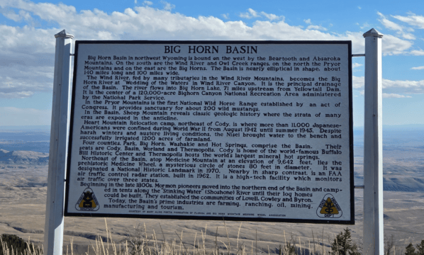
Leaving Lovell, Highway 14A initially travels through the broad landscape of the Bighorn Basin. The dry terrain, distant mountain ranges and enormous Wyoming sky create a sense of openness that seems to stretch in every direction.
That changes quickly as the highway reaches the base of the Bighorns.
The road begins a steep and winding ascent, climbing through a series of curves toward the high country. Grades reach 10 percent in places, making Highway 14A one of the steeper paved mountain routes in Wyoming. Drivers should take their time, use lower gears when descending and make use of the available turnouts.
The climb rewards travelers with increasingly impressive views. From overlooks along the western face of the mountains, much of the Bighorn Basin can be seen spread across the landscape below. On a clear day, the distant Absaroka Mountains rise along the western horizon.
It is the kind of view that makes the towns, farms and highways on the basin floor appear remarkably small.
A Journey Through Changing Landscapes
One of the most distinctive features of Highway 14A is how rapidly the surroundings change.
Travelers begin among the sagebrush and dry hills near Lovell before climbing past rugged limestone formations and steep canyon country. Farther up the mountain, the landscape opens into grassy high-elevation plateaus interrupted by stands of spruce and pine.
Wildflowers bring splashes of color to the mountain meadows during the summer. Small creeks cross the surrounding country, while side roads lead toward waterfalls, campgrounds, fishing areas and hiking trails.
The Forest Service describes the Medicine Wheel Passage region as a place where visitors encounter both high-elevation plains and deep canyon country. Scenic stops along the route include the Crystal Creek, Beaver Creek and Bald Mountain overlooks. Nearby recreational attractions include Porcupine Falls and Bucking Mule Falls, although reaching them requires leaving the highway and traveling on forest roads.
Watch for Wildlife
The constantly changing habitats along Highway 14A make it an excellent wildlife-viewing route.
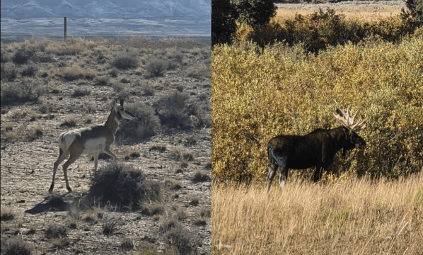
Mule deer are commonly seen near the road, particularly during the quieter morning and evening hours. Elk may appear in forest openings or across the high meadows, while moose are sometimes spotted in wet areas areas along creeks and the North Tongue River.
Travelers may also encounter yellow-bellied marmots sunning themselves on rocky slopes. Coyotes, foxes and black bears inhabit the surrounding forest, although sightings are less predictable.
Above the roadway, watch for hawks and golden eagles riding the mountain air. Smaller birds, including mountain bluebirds, add flashes of color to the open country.
Wildlife can enter the highway unexpectedly, so drivers should remain alert and observe animals from a safe distance. Pull completely into a turnout before stopping for photographs, and never approach or feed wildlife.
The Medicine Wheel
One of the route’s most important destinations is the Medicine Wheel/Medicine Mountain National Historic Landmark.
Located near the summit at nearly 10,000 feet, the site contains a stone wheel and associated features within a landscape that remains culturally and spiritually important to numerous Native American tribes. Archaeological evidence indicates that Indigenous people have visited the Medicine Mountain area for thousands of years.
Visitors normally walk approximately 1.5 miles from the lower parking area to reach the Medicine Wheel. The site remains an active place of ceremony and prayer, so visitors should be respectful, avoid disturbing offerings and follow instructions from on-site interpreters. Access conditions and operating dates vary because of the high elevation. Learn more from the Bighorn National Forest.
Arriving at Burgess Junction
After the steep climb, Highway 14A crosses the open high country before reaching Burgess Junction, where it meets U.S. Highway 14.
From there, travelers can continue east toward Dayton and Sheridan or turn south toward Shell Canyon and Greybull. Those who have time can extend the journey along the Bighorn Scenic Byway, creating an even longer exploration of the mountain range.
Plan Ahead for a Seasonal Drive
Highway 14A is a seasonal route. WYDOT generally closes a 22-mile mountain section around the end of November because heavy snow, drifting and limited winter traffic make regular snow removal impractical. The highway normally reopens by Memorial Day weekend, although the exact date depends on weather and road conditions.
Even during summer, mountain weather can change rapidly. Travelers should bring extra clothing, water and a full tank of fuel. Drivers of large recreational vehicles or vehicles pulling trailers should carefully consider the steep grades and winding descent.
Check current conditions through WYDOT’s road information service before beginning the trip.
Whether driven as part of a larger Wyoming journey or explored as a day trip from Lovell, Highway 14A offers an unforgettable introduction to the Bighorn Mountains. Its combination of immense views, changing ecosystems, cultural history and wildlife makes it one of the Bighorn Basin’s most rewarding scenic drives.
Subscribe to Stay Up to Date with Everything From Bighorn Basin Explorer
 Bighorn Basin Explorer
Leave a comment